Resources
- https://www.mountainproject.com/route/112133991/sky-pilot
- https://wanderhigh.com/2013/09/01/idaho-alpine-climbing-sky-pilot-5-8-iii-on-peak-11280-in-the-pioneer-range/
- http://fadgenfamily.blogspot.com/2018/09/sky-pilot-peak-11280.html
- http://scidaho.blogspot.com/2010/07/sky-pilot-iv-58-wildhorse-creek.html
- Video of P3: https://www.youtube.com/watch?v=MRO97fJ3JiU
- https://www.tapatalk.com/groups/idahooutdoorsforum/sky-pilot-5-7-trad-alpine-1200-ft-11-pitches-grade-t5900.html
Schedule
- ~2 hr approach (both a mountain guiding service and wanderhigh’s blog said 2 hrs)
- ~6 hrs climbing (wanderhigh)
- ~3 hrs back to the car (wanderhigh)
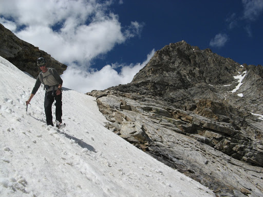
Descent
After summiting, we descended the south side, followed the steep basin down to the creek (which we quickly bathed in while crossing), and then followed the road back to our car for a round trip of 11 hours.
wanderhigh
After some lunch on the summit and hanging out with the Ladybugs, we descended to the southwest into the adjacent basin, below the impressive face of Goat Peak. Fortunately there was still some snow and plunge stepping was much easier than navigating steep scree and cliffs. Once back at treeline we spooked a herd of elk hanging out in the lush alpine meadows getting fat on summer’s greenery. We dropped back down into Wildhorse Creek and returned to the mine for another cold creek crossing on sore feet. What a great day in the alpine!
http://scidaho.blogspot.com/2010/07/sky-pilot-iv-58-wildhorse-creek.html
The descent was definitely the crux and wondering if there is a better way?
Upon reaching the summit of Sky Pilot, you’ll need to descend the south face of the mountain. This descent requires scrambling over large loose boulders and 3rd-4th class ledges which seem to never end. After making your way down to the base of the amphitheater, you’ll need to follow game trails and hug the terrain to the north. With enough bushwhacking you’ll make it back to the Wildhorse Creek. Follow the creek until you reach your original crossing.
https://www.tapatalk.com/groups/idahooutdoorsforum/sky-pilot-5-7-trad-alpine-1200-ft-11-pitches-grade-t5900.html
With respect to the descent from Peak 11280, people have told me that there is a cairn marking a fairly direct path to the mine if you traverse down and left above timberline. This is near where your descent line is marked on the aerial photo. I have not done this. My best descent has been to traverse down and far right (descenders right) from the small ponds. You can get to the creek on the west side of Mustang Peak through partial clearings in the forest. There is a Forest Service trail in the valley. Take it down. It seems like a long detour, but the walking is easy because you are in sparse trees, followed by a good trail, and ultimately the road. If I go up there again, I will use this route.
There is another direct descent from the summit directly down the scary north side from the west saddle. It follows a ramp that cuts across the north face and goes quickly to the valley floor. You can hike back to the lake and the beginning of Sky Pilot in about an hour. The ramp ranges from about 50 to 1-2 feet wide, is semi technical (Class 4), and is covered with steep unstable talus. It also holds snow until late summer. I have descended it, occasionally using a rope for safety. It is dangerous because it’s very loose with a big drop below. It gets you back to the base really quick. Hopefully not too quick. I will not do it again unless I am in a very big hurry.
https://www.tapatalk.com/groups/idahooutdoorsforum/sky-pilot-5-7-trad-alpine-1200-ft-11-pitches-grade-t5900.html