Gear
- Personal gear
- Ice axe
- Footwear
- Just microspikes might be fine? Low is only 50 degrees, doesn’t really have steep snow
- Alternatively crampons are most common
- 3L water (no major water source along route)
- Food for 10-12 hr day
- Sunglasses
- Sunscreen
- Helmet
- Harness with…
- Belay device
- 3 locking carabineers
- 2 prusiks
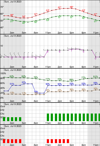
- Clothing for temps from 55 degrees to 68 degrees, partly sunny, low/mild winds, 30% chance rain
- Group gear (Alexis/Andrew bringing)
- 60m rope?
- 2 pickets and pulleys
- Water filter
Itinerary
- 4:00 AM – Gary drives to https://goo.gl/maps/RsaYj7p14p5wjLM77 on Mountain Loop Highway (the base of the forest road that goes up to Bedal) (⚠️ make sure to take north way through Darrington, south way through Mountain Loop Highway is closed at Bedal)
- 5:00 AM – Alexis and Andrew bike 5 miles of the closed road from Barlow north
- 5:30 AM – Meet at https://goo.gl/maps/RsaYj7p14p5wjLM77 on Mountain Loop Highway, drive rest of the way up
- 5:45 AM – Trailhead
- 6:00 AM – Hiking (5 miles, 5,000 ft gain, 6 hours)
- 12:00 PM – Top
- 12:30 PM – Descend and hike down (5 hours)
- 5:30 PM – Car
- 5:45 PM – Mtn Loop Highway
- 6:30 PM – Alexis and Andrew back at car after biking
Weather
Dawn: 4:37 AM, Sunrise: 5:15 AM, Sunset: 9:07 PM, Dusk: 9:45 PM.
Should be 55 degrees in the morning, getting to a high of 61 when we get to the summit, and then high of 68 when we get back to the car